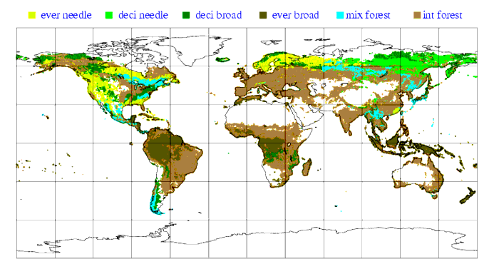
10.7 Vegetation parameters
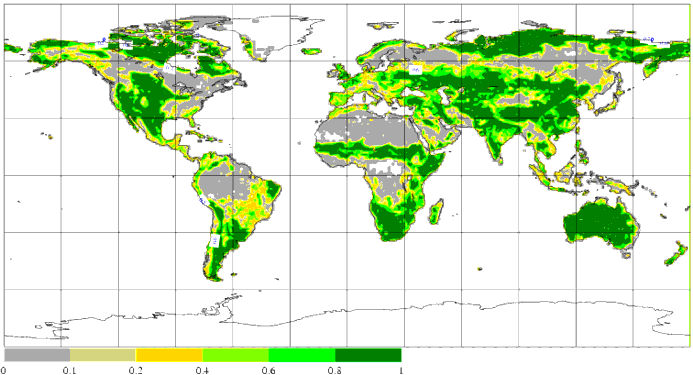
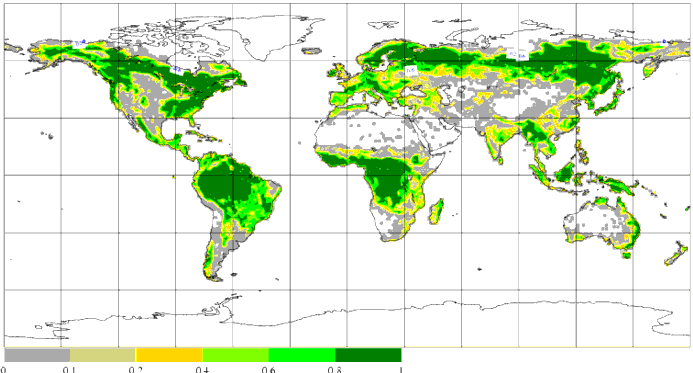
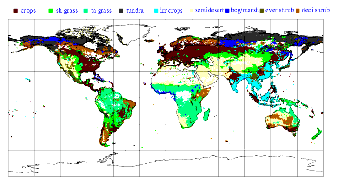
Vegetation is represented by 4 climatological parameters: vegetation
cover of low vegetation, vegetation cover of high vegetation, low
vegetation type and high vegetation type. These parameters are derived
from the 2'30" GLCC data by averaging over the target grid squares. The
fractional covers for low and high vegetation are obtained by combining
the fractions from all the low and high vegetation types of Table 10.1.
The index of the dominant low and high vegetation types are also coded
as climatological fields for use by the land surface scheme. The latter
two fields can not be interpolated by standard procedures to another
resolution. The resulting fields are shown in Fig. 10.8 , Fig. 10.9 , Fig. 10.10 and Fig. 10.11 . Table and Table 10.3 contain statistical information on the number of points in each vegetation class.
Table 10.2 Percentage of land points at T511 for each low vegetation type
|
|
|
|
|
1
|
Crops, Mixed Farming
|
22.1
|
|
2
|
Short Grass
|
10.0
|
|
7
|
Tall Grass
|
13.0
|
|
9
|
Tundra
|
8.9
|
|
10
|
Irrigated Crops
|
4.7
|
|
11
|
Semidesert
|
13.5
|
|
13
|
Bogs and Marshes
|
2.0
|
|
16
|
Evergreen Shrubs
|
1.5
|
|
17
|
Deciduous Shrubs
|
4.6
|
|
20
|
Water and Land Mixtures
|
0
|
|
-
|
Remaining land points
without low vegetation
|
19.7
|
Table 10.3 Percentage of land points at T511 for each high vegetation type
|
|
|
|
|
3
|
Evergreen Needleleaf Trees
|
7.1
|
|
4
|
Deciduous Needleleaf Trees
|
3.3
|
|
5
|
Deciduous Broadleaf Trees
|
6.3
|
|
6
|
Evergreen Broadleaf Trees
|
12.8
|
|
18
|
Mixed Forest/woodland
|
3.9
|
|
19
|
Interrupted Forest
|
29.6
|
|
-
|
Remaining land points
without high vegetation
|
37.0
|
)
Figure 10.8 Fractional cover of low vegetation.
Figure 10.9 Fractional cover of high vegetation.
Figure 10.10 Low vegetation type
Figure 10.11 High vegetation type